SHEPPARTON, Victoria, Australia–When spring came to the Riverine Plain of northern Victoria in September 1989, Peter Avram’s peach orchard slowly awakened and burst into leaf, just as it always had before.

Avram expected a good crop, one that might bring $40,000 in sales once the fruit was picked and packed. But two months later he had nothing but a forest of dead wood. More than 2,000 trees, most of them in the prime of their productive lives, got a fatal case of root rot. They were killed by a flood from below, drowned in an unseen tide of rising groundwater caused by 150 years of over-irrigation and deforestation.
For a century and a half, Australians like Avram have farmed the low inland plains along the River Murray. They cut down forests of eucalyptus trees to bring in the sun, and laced the countryside with canals to bring in the water. In doing so, they wrought huge changes in the natural cycles of rainfall and runoff. First they removed the land’s protective natural sponges, its trees. Then they poured unprecedented amounts of water on the denuded soil. For a long time they got away with it.
But now, like their cousins in irrigated regions around the world, they are learning there is a price to be paid for trying to improve upon nature. In the United States, Mexico, China, the Soviet Union, India, Pakistan, Iraq, Syria, Egypt, Somalia and a dozen other nations, vast expanses of farmland are falling victim to the Achilles’ heel of irrigation–poor drainage.
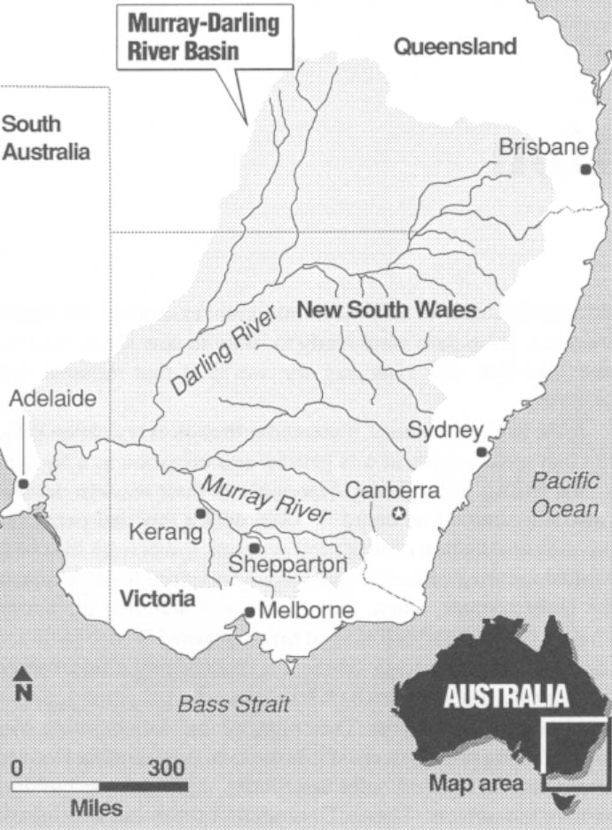
Aborigines had been living in Australia for 40,000 years when the first European settlers arrived in the Riverine Plain in the early 19th century. Yet when Maj. Thomas Mitchell, the Australian explorer, crossed northern Victoria in 1836,he found a landscape that was only slightly changed from what the first Aborigines saw. Thick forests of eucalyptus, the predominant tree of Australia, crowded the low hills along the continent’s eastern and Southern coasts. Below them, to the north, sparsely wooded savannas gave way to a vast, open grassland on the west. The largest river on the continent, the Murray, snaked across the plains, emptying into the Southern Ocean.
It took Maj. Mitchell’s successors only a few years to make their mark on this wilderness. First, the Merino breed of sheep was brought in from Spain, and soon wool barons were running their herds on spreads of 300,000 acres, usually without bothering to Secure title to the land. Then gold was discovered at Bendigo in 1851, and hordes of miners set out for Victoria. In a single decade, the state’s population soared from 77,000 to 540,000. But the gold rush fizzled out as quickly as it began, and the government then was faced with a stupefying social problem: What to do with a lot of restless immigrant ex-miners. Desperate Victorian politicians were ready to listen to new ideas. And the new idea that was sweeping the world at that moment was irrigation.
In the late 19th century, it seemed as though every nation in the English speaking world was getting into irrigation in a big way–the British in India, the Americans in their western deserts. Australia climbed on board in 1886 with a law that permitted private construction of irrigation systems. But private irrigation ventures in Australia ultimately proved no more feasible than in the United States, where they failed with stunning regularity. Finally, both countries followed the example of British India and resigned themselves to government-sponsored irrigation schemes.
Australia and America both built powerful irrigation agencies within their governments. They plunged into dam building with the zeal of the proselytized. While the U.S. was building Hoover, Glen Canyon, Grand Coulee and Shasta, Australia was building its own monuments: Hume, Dartmouth, Eildon and Burrinjuck. So it’s not surprising that both the Australian and the American irrigation juggernauts broke down about the same time. In the U.S., the causes were varied– the escalating costs of water projects, a massive shift of population from farms to cities (and therefore a shift of political support away from irrigation); a controversial plan to build two high dams in the neighborhood of the Grand Canyon. In Australia, there was only one cause–a head-on collision with poor drainage.
Virtually every irrigated nation in the world fights a constant war against poor drainage. But few of those countries have struggled with the drainage nemesis for as many years as Australia has. In the low-lying region around Kerang, where irrigation began in the 1880s, pioneer farmers were abandoning their land after just a decade because of a salting of the soil caused by poor drainage.
Avram’s farm lies 100 miles southeast of Kerang. Irrigation began later in his area, and the water tables around Shepparton were lower to start with, so drainage didn’t become a problem in his area until 1956, one of the wettest winters in Australia’s history. Heavy rains fell all across Victoria. With the soil already wet from irrigation, the rainwater had nowhere to go but straight down to the water table. Dozens of orchardists in the area around Shepparton watched their trees drown in the resulting underground flood.
The same thing happened in 1974, another wet winter, and farmers began to drill wells to pump out the high groundwater periodically. But in each of the wet winters. the Avram family’s orchard was untouched. It seemed charmed.
“Never in our mind did we think we would lose our trees here, because we never lost them before,” Avram said. “Fifty-six was the wettest year, and this place was the only place that survived, so…”
The past two winters, 1988 and 1989, have been extremely wet. But when last spring came, Avram was as confident as always. Soon, however, he got a shock.
“It started to leaf out, and then the blossoms came, and that was it,” he said. “The blossoms came, and before the petals fell the trees started dying.
“It was the stress. The trees were starting to take from the roots, and the roots said, ‘No more.’ “
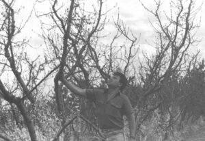
In November, while all around him the orchards were setting a heavy crop of fruit, Avram stood amid dead and dying trees. Here and there a few pathetic little leaves clung to the ends of twigs; little green balls of fruit the size of marbles hung like Christmas ornaments from the gray branches. Avram reached up, pulled a branch toward him, and broke off the end. He put the splintered wood to his nose and made a face.
“Dead wood,” he said. “You break a stick, and it just smells an off smell, like there’s dead fruit lying around. The roots just go black, they rot. And when they go black, that’s it.”
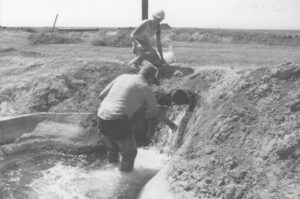
Now Avram can only wish he had invested in wells to lower the water table, or in water-conserving irrigation gear, such as sprinklers. If he had, the soil might not have been so waterlogged. It might have been able to absorb the winter rains better, and his trees might not have drowned so quickly.
“We know now,” he said. “We have to put the pumps in, we have to hill up the trees, put sprinklers in. And that’s going to cost a lot of money.”
There is no little irony in what is happening in the Murray basin. Australia is the driest by far of the world’s inhabited continents. Yet its biggest environmental problem is one of too much water. If nothing is done in the next decade or so, Australia’s agricultural heartland may turn into nothing more than a soggy, saline swamp.
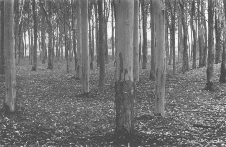
Civilization is the sole cause. For thousands of years before Europeans arrived, the hydrological cycle in northern Victoria was exquisitely balanced by nature alone. Rain fell on the uplands just as it does now. But the vast eucalyptus forests, their leaves transpiring prodigious amounts of moisture, put most of the water right back into the atmosphere.
The English settlers couldn’t see that happening, of course. All they saw when they looked at the eucalyptus was a source of firewood, or an obstacle to be done away with in the interest of better pastures. For years, starting in the 1860s, the Crown actually required settlers to clear the trees from their land before gaining title to it. And as late as 1983, the Australian government offered tax incentives for land clearing–in other words, a bounty on trees. In the 1880s, half a million tons of timber was shipped by rail to Melbourne every year, mainly for firewood. Today, millions of sheep graze where forests once stood.
Deforestation was the first of two deadly changes that the settlers made in Australia’s ecology. The second was the introduction of irrigation. First, they removed the forests that had sopped up nature’s excess rainfall, then they imported still more water to grow crops on the newly cleared land. In planting paddocks of wheat or maize and pastures of clover, the settlers were also planting, unwittingly, the seeds of their own destruction.
It took a while for the damage to become apparent. Except in places like the Kerang area, the water table was deep at first, a hundred feet or more. Over most of the Murray basin, it took almost a century for the ground to fill up. But once it happened, the crisis began. Down to the bedrock the earth was slowly filled–filled with excess rainfall from the old forests and excess irrigation water from the new farms, filled until it finally could take no more. From that day on, when the winter rains came it was like pouring water on an already sodden sponge. The precipitation couldn’t soak in, and because the land was nearly flat it couldn’t run off either. It just sat there, pooling up atop the water that was already in the ground.
When he crossed Victoria in 1836, Maj. Mitchell made a stop in the Tragowel Plains near the present site of Kerang. He climbed Pyramid Hill, an 800-foot mound of decomposing granite in the center of a broad grassy plain. Looking across the plain from the high ground, he saw the shallow creeks, the gentle slope of the land, and the fine clayey soil. He proclaimed the region ideal for irrigation. He was wrong.
Late in 1989, Ken McDougall stood atop the same hill and gazed into the distance toward the dying town of Pyramid Hill, population 540, a quarter of them older than 60.
Most towns in rural Victoria are surprisingly clean and prosperous looking. Pyramid Hill is an eyesore of peeling paint, pot-holed streets and lawns of bare earth.
The surrounding countryside isn’t much better. Bullock Creek snakes past the foot of the hill, separating hill from town. Its banks are lined with black skeletons of dead eucalyptus trees. They were killed when groundwater seeped upward into their root zones, wicking toward the surface as a droplet of water wicks into the corner of a paper towel. Partly because much of the Tragowel Plains once lay under the ocean, the subsoil contains a lot of salt, which the groundwater dissolved and carried along to the surface. The water then evaporated, leaving the salt behind, and the trees were poisoned.
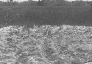
Beyond the creek lie vast pastures in a checkerboard of brown and green. The brown ones are obviously dying. The green ones look healthy, but in fact they are only slightly less salt-affected than the brown ones. MacDougall’s experienced eye can spot the signs of salting even in the greenest pastures. Instead of clover and other good forage, the pastures are sprouting salt-tolerant plants that sheep shun. A good pasture can graze six sheep per acre; these, he says, can graze fewer than three.
The Tragowel Plains contain 520 struggling farmers and their families. Many, including MacDougall, have been forced to take jobs off the farm because their soil has gone bad.
“I used to drive a milk truck around at night to make ends meet,” MacDougall said. “Now I’m working on salinity for the Rural Water Commission. I’d like to think I’m working part-time and farming full-time, but I’m not quite there yet.”
MacDougall may know more about the drainage problem than anyone else in the Tragowel Plains. Besides holding a Rural Water Commission job, he is also chairman of a community group that the state government has set up to work on the drainage problem. It’s an unusual arrangement, practically unheard of in America. The government gave the group money to hire consultants, put its own staff at the group’s disposal, and told the group to come up with a solution it could live with. It did, and the plan is now under review in Melbourne, the capital. Similar plans for three other regions are also being reviewed.
Graham Hunter, manager of the Salinity Bureau in the state’s Department of the Premier and Cabinet, described the community group approach as one borne almost of desperation. In the past, Hunter said, the government’s experts would regularly come up with plans for solving an area’s drainage problems. The plans would just as regularly be rejected. In one case, the farmers might think the solution would cost them too much. In another, they might object to being told they would have to shift to salt-tolerant crops and away from sensitive clovers. After a leftist Labor Party government took over the parliament in 1983, the issue was finally thrown back to the farmers.
“I think you’d say we’re empowering the community to make its own decisions,” Hunter said. The community groups spent two years studying the technical data, debating the options and writing their plans to send to Melbourne. The results, Hunter said, have been “very interesting. We now have farmers on these groups who are as conversant with the issues as most of the technical experts.”
But some of the plans sent to Melbourne look to be fatally flawed. In Shepparton, for example, the community group said it wanted to use the River Murray as a dump for drainage water containing 178,000 tons of salt per year, far more than is allowed under an existing agreement to control the river’s salinity down stream, where it is a source of drinking water. In another area near Rochester, the community group came up with a plan that seems acceptable to everybody except the other farmers in the region, who oppose it by a 4-1 margin.
Neither of those areas is quite like the Tragowel Plains; they are still prosperous. Farmers in the Tragowel Plains and other areas near Kerang, on the other hand, are on the ropes. And that, MacDougall said, may account for their support of his working group’s plan. It calls for farmers to simply sacrifice part of their land to salt-tolerant plants, and irrigate only the less-affected areas. By careful management, the farmers might be able to coax the salt-affected areas to grow something that sheep will eat, such as a species of Atriplex known locally as saltbush. But mostly the farmers will simply be trying to keep their good pastures from going bad by using the salty areas as a relief valve, where the rising groundwater can come to the surface and evaporate, sparing the good pastures.
“Everybody’s on their last legs here,” MacDougall said. “People start to pull together in a crisis, and we’ve got a crisis on our hands.”
©1990 Russell Clemings
Russell Clemings, a science writer from the Fresno Bee, is writing about salinity, selenium and the future of irrigation.